
Sure! Here’s a detailed set of notes on the Aare River, covering its geography, significance, ecology, and more.
🌊 Aare River – Detailed Notes
🗺️ Overview
- The Aare River (also spelled Aar) is the longest river entirely within Switzerland.
- Length: Approximately 295 kilometers (183 miles).
- It is a tributary of the Rhine River, which it joins near Koblenz, Switzerland.
📍 Source and Course
- Source:
- The river originates in the Bernese Alps, specifically from the Aare Glacier in the Grimsel region, near the Finsteraarhorn in the canton of Bern.
- Path:
- Upper Aare Valley – flows through Lake Grimsel and Lake Brienz.
- Interlaken – flows between Lake Brienz and Lake Thun.
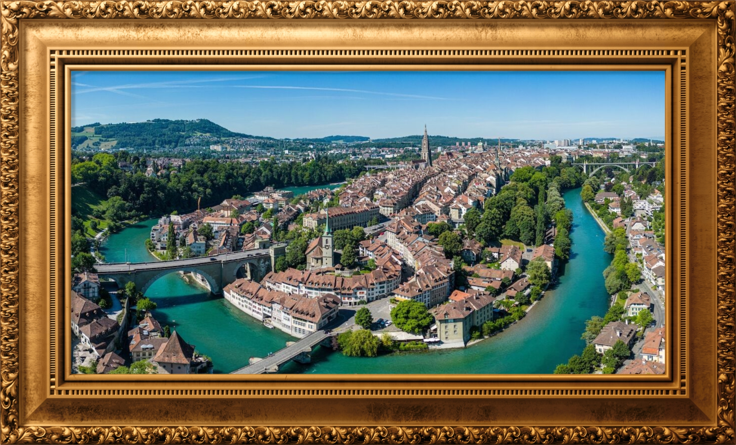
- Bern – flows through the Swiss capital in a scenic loop; important for the city’s geography and aesthetics.
- Aargau – flows past Aarau and then joins the Rhine at Koblenz.
🏞️ Major Cities and Towns Along the Aare
- Interlaken
- Thun
- Bern (capital of Switzerland)
- Solothurn
- Aarau
- Brugg
- Koblenz (confluence with the Rhine)
🌊 Major Lakes Along the Aare
- Lake Grimsel
- Lake Brienz
- Lake Thun
- Lake Wohlen
- Lake Biel (via the Hagneck Canal)
⚡ Hydropower and Economic Importance
- The Aare is heavily utilized for hydroelectric power generation.
- Numerous dams and power stations have been constructed along its course.
- It contributes significantly to Switzerland’s renewable energy supply.
- Also used for drinking water, irrigation, and flood control.
🌿 Ecology and Environment
- The Aare River supports a rich biodiversity:
- Fish species such as trout, grayling, and eel.
- Important habitat for aquatic plants and animals.
- Subject to environmental protection laws to preserve water quality.
- Efforts are made to maintain ecological flow, especially where hydropower infrastructure is present.
🏛️ Cultural and Historical Significance
- Integral to the development of Bern, with the Old Town built in a meander of the Aare.
- Historically, it served as a natural defense and a trade route.
- Inspired many artists, poets, and photographers for its scenic beauty.
🛶 Recreation and Tourism
- Popular for swimming, rafting, and canoeing, especially in summer.
- The Aare swim in Bern is a famous local activity.
- Walkways and cycle paths along the river are popular with tourists.
🔄 Tributaries
- Notable tributaries include:
- Reuss
- Limmat
- Zihl/Thielle
- Emme
- These rivers contribute to the Aare’s flow and its role in Swiss hydrology.
📉 Flooding and Management
- The Aare has a history of seasonal flooding.
- Extensive flood protection projects have been undertaken.
- Notable example: the Jura water correction projects which redirected and stabilized water flow.
🌍 International Importance
- While the Aare itself lies wholly within Switzerland, its waters ultimately join the Rhine River, which flows through Germany, France, and the Netherlands, making it part of the larger Rhine river basin system.
Summary
The Aare River is not only the longest river entirely within Switzerland, but also a vital natural resource. It supports energy production, biodiversity, tourism, and urban development, especially in the city of Bern. Its scenic beauty and environmental significance make it one of the most important rivers in the Alpine region.
Certainly! Here’s a detailed set of notes on the Location of the Aare River, focusing specifically on its geographical positioning, route through Switzerland, and how it connects with other major features and regions.
📌 Location of the Aare River – Detailed Notes
🌍 Continent and Country
- Continent: Europe
- Country: Switzerland 🇨🇭
- The Aare River is entirely within Swiss territory.
- It is the longest river entirely in Switzerland, with a total length of approximately 295 km (183 miles).
🏔️ Source Location
- Origin:
- The Aare River originates in the Bernese Alps.
- Specific location: Aare Glacier near the Grimsel Pass, in the canton of Bern.
- Elevation at source: Roughly 2,300 meters (7,546 feet) above sea level.
📍 Course Through Switzerland
The Aare flows generally northeastward across central Switzerland.
Major regions and cantons it flows through:
- Canton of Bern:
- Source region (Grimsel)
- Lakes: Lake Grimsel, Lake Brienz, Lake Thun
- Towns/Cities: Meiringen, Interlaken, Thun, Bern
- Capital city Bern is built on a loop of the Aare River.
- Canton of Solothurn:
- Town: Solothurn, a historic baroque town on the Aare.
- Canton of Aargau:
- Cities: Aarau, Brugg, Koblenz
- Known for hydroelectric power plants along the river.
🌊 Lakes Connected by or Drained Into by the Aare
The Aare flows through or near several major lakes:
| Lake | Connection |
|---|---|
| Lake Grimsel | Fed by glacial melt, upper catchment of Aare |
| Lake Brienz | Aare flows into it |
| Lake Thun | Aare flows out of it |
| Lake Wohlen | Artificial reservoir near Bern |
| Lake Biel | Reached via the Hagneck Canal, part of Jura water correction |
🛤️ Confluence and Endpoint
- Final destination: The Aare joins the Rhine River at Koblenz, canton of Aargau.
- Confluence Location:
- Near the border with Germany, but still within Swiss territory.
- The Aare contributes a larger volume of water to the Rhine at this junction.
🏞️ Relative Location and Borders
- The Aare is entirely within Swiss national borders.
- It does not cross into other countries but influences international river systems via the Rhine River, which flows through Germany, France, and the Netherlands.
🧭 Geographical Coordinates
- Source (Aare Glacier): Approx. 46.55° N, 8.33° E
- Mouth (Confluence with the Rhine): Approx. 47.61° N, 8.23° E
🧭 Nearby Major Geographical Features
- Bernese Alps – Source region in the high Alps.
- Swiss Plateau – The river traverses this densely populated and agriculturally important area.
- Jura Mountains – To the north of its course, near the lower Aare and Lake Biel.
🗺️ Map Summary (Verbal Description)
If looking at a map of Switzerland:
- The Aare starts in the south-central region (Alps),
- Flows northwest into the lakes around Interlaken and Bern,
- Turns northeast, passing Solothurn and Aargau,
- Finally merges into the Rhine in the north, near Koblenz (Switzerland).
✅ Summary
- Location: Entirely in Switzerland
- Begins: Aare Glacier, Bernese Alps (canton of Bern)
- Ends: Joins the Rhine River at Koblenz (canton of Aargau)
- Regions crossed: Bern, Solothurn, Aargau (and affects Neuchâtel via canals)
- It plays a key role in shaping the geography of central and northern Switzerland.
Certainly! Here’s a detailed set of notes on the Physical Characteristics of the Aare River. This includes information on its length, source, gradient, flow, drainage basin, and more.
🌊 Physical Characteristics of the Aare River – Detailed Notes
📏 Length
- The Aare River is approximately 295 kilometers (183 miles) long.
- It is the longest river entirely within Switzerland.
🏔️ Source
- Origin: Aare Glacier in the Bernese Alps.
- Specific location: Near the Grimsel Pass, in the canton of Bern.
- Elevation at source: Around 2,300 meters (7,546 feet) above sea level.
- Fed by glacial meltwater from the Finsteraarhorn region.
🏞️ Mouth
- Terminates at: Confluence with the Rhine River.
- Location of confluence: Near Koblenz, in the canton of Aargau, Switzerland.
- Elevation at mouth: Around 311 meters (1,020 feet) above sea level.
📉 Elevation Drop and Gradient
- Total elevation drop: Approx. 1,989 meters (6,525 feet) from source to mouth.
- Average gradient: Varies along its course.
- Upper course: Steep gradient in the alpine region (fast-flowing, narrow, erosive).
- Middle and lower course: Gentler gradient (slower flow, meandering, broader valley).
🌐 Drainage Basin (Catchment Area)
- Size: Around 17,800 square kilometers.
- Covers a significant portion of the Swiss Plateau and parts of the Jura and Alpine regions.
- Includes several tributary systems and connected lakes.
🚿 Discharge and Flow Rate
- Average discharge at the mouth (where it joins the Rhine):
- Approximately 560 m³/s (cubic meters per second).
- Can vary significantly with seasonal snowmelt and rainfall.
- The Aare actually contributes more water to the Rhine than the Rhine itself at the confluence.
🛶 River Type and Flow Characteristics
- Perennial river: Flows year-round due to glacial sources and regular precipitation.
- Flow regime: Alpine glacial regime—strong seasonal variation.
- High flow in late spring and summer due to snow and glacier melt.
- Low flow in winter.
🏞️ Valley and Channel Form
- Upper course: Deep, narrow alpine valleys with steep gradients and V-shaped profiles.
- Middle course: Broader U-shaped valleys with more meandering.
- Lower course: Wider floodplains, artificial embankments, and managed flow systems.
🌊 Tributaries
The Aare is fed by several important rivers:
- Left-bank tributaries:
- Emme, Suhre
- Right-bank tributaries:
- Limmat, Reuss, Zihl/Thielle
These tributaries significantly influence its volume and hydrology.
🏞️ Lakes Along Its Path
- The Aare flows through or near several major lakes:
- Lake Brienz
- Lake Thun
- Lake Wohlen
- Lake Biel (via canal connection)
- These lakes regulate flow, act as sediment traps, and help prevent flooding.
⚡ Human Alterations and Hydropower
- The river is heavily dammed and regulated:
- Numerous hydropower stations along its length.
- Artificial channels and reservoirs manage flow for energy, flood protection, and navigation.
- Example: Hagneck Canal, part of the Jura water correction project, redirected the river to help manage wetlands and floods.
🌿 Sediment Load and Geology
- Upper course: High sediment load due to glacial and alpine erosion (rocky, gravely).
- Middle and lower course: Finer sediments deposited in floodplains and lakes.
- The geology of the basin includes limestone, granite, schist, and glacial deposits.
📌 Geographical Zones Along the Aare
- Alpine Zone – Glacial origin, steep gradients.
- Pre-Alpine Lakes Region – Lake Brienz and Lake Thun.
- Swiss Plateau – Includes Bern and Solothurn; fertile land, slower flow.
- Aargau Lowlands – Densely populated, industrial areas, hydroelectric developments.
✅ Summary Table
| Characteristic | Description |
|---|---|
| Length | 295 km (183 miles) |
| Source | Aare Glacier, Bernese Alps |
| Mouth | Rhine River at Koblenz, Aargau |
| Elevation Drop | ~1,989 meters |
| Average Discharge | ~560 m³/s |
| Drainage Area | ~17,800 km² |
| Tributaries | Limmat, Reuss, Emme, Suhre |
| Lakes | Brienz, Thun, Wohlen, Biel |
| Flow Type | Alpine glacial regime |
Certainly! Here’s a detailed set of notes on the Course of the Aare River, outlining its journey from source to mouth, key geographical features along the way, and major changes in landscape and usage.
🗺️ Course of the Aare River – Detailed Notes
📌 Overview
The Aare River follows a distinctive path through central and northern Switzerland, flowing from the Bernese Alps to its confluence with the Rhine River. It passes through several cantons, alpine valleys, lakes, urban centers, and agricultural plains, shaping both the landscape and human settlement.
🏔️ 1. Upper Course – Alpine Region
Location: Bernese Alps
Canton: Bern
Key Features:
- Source: Aare Glacier near Grimsel Pass (approx. 2,300 m elevation).
- Flows through steep, narrow gorges and rocky valleys.
- Receives water from:
- Finsteraarhorn glaciers.
- Oberaarsee (a reservoir).
- Forms Lake Grimsel, an artificial reservoir used for hydroelectric power.
- Passes through the Haslital Valley near Meiringen.
- Famous site: Aare Gorge (Aareschlucht) – a deep limestone gorge near Meiringen, popular with tourists.
🌊 2. Middle Course – Lake Region and Swiss Plateau
Canton: Bern
Key Lakes:
- Lake Brienz
- Lake Thun
Interlaken Region:
- Aare flows into Lake Brienz and then out at Interlaken.
- Continues westward into Lake Thun.
- These lakes help moderate the river’s flow and reduce flooding risk.
Thun to Bern:
- Exits Lake Thun at the town of Thun.
- Moves northwest through the Swiss Plateau.
- Flows through the city of Bern in a dramatic U-shaped loop.
- Bern’s historic Old Town is nestled within this loop.
- Bridges like the Kirchenfeld Bridge and Nydegg Bridge cross the river.
- This stretch is popular for recreation (especially river swimming in summer).
🌄 3. Lower Course – Agricultural Lowlands and Urban Areas
Cantons: Bern, Solothurn, Aargau
Key Towns/Cities: Solothurn, Aarau, Brugg, Koblenz
Bern to Solothurn:
- Passes through Lake Wohlen (an artificial reservoir).
- Flows north into the Seeland region (Three Lakes Region).
- Connected to Lake Biel via the Hagneck Canal (part of Jura water correction).
- This manages floods and directs water from the Aare into the lake.
Solothurn:
- Historic baroque city on the Aare’s banks.
- Slower-moving river through flat terrain.
Aargau:
- Flows past Aarau (capital of canton Aargau).
- Major hydropower stations operate in this region.
- River becomes wider and more controlled through canals, weirs, and dams.
🌉 4. Mouth – Confluence with the Rhine
Final destination: Joins the Rhine River at Koblenz (Switzerland), near the German border.
Key Point:
- The Aare actually contributes more water to the Rhine than the Rhine does at the point of confluence.
🛶 Hydrological and Geographic Importance
- Flows through multiple hydrological zones:
- Alpine zone: Steep, fast, erosive.
- Lake zone: Regulated by large lakes.
- Plateau zone: Fertile plains, urban development.
- Provides water for agriculture, drinking, industry, and energy.
🧭 Course Summary Table
| Segment | Features | Key Locations |
|---|---|---|
| Upper Course | Glacial, steep, mountainous | Grimsel Pass, Meiringen, Aare Gorge |
| Middle Course | Lake system, scenic valleys | Interlaken, Lake Thun, Bern |
| Lower Course | Broader valley, flood control, hydro use | Solothurn, Aarau, Aargau plain |
| Mouth | Confluence with Rhine River | Koblenz (Switzerland) |
✅ Summary
- Starts in the Bernese Alps as a glacial stream.
- Passes through lakes, gorges, and cities (including Bern).
- Ends in the northern lowlands, joining the Rhine River.
- The Aare shapes landscapes, supports ecosystems, and plays a vital role in Swiss water management and energy production.
Certainly! Here’s a detailed set of notes on the Tributaries of the Aare River, covering both major and minor tributaries, their origins, and their significance to the Aare’s flow and hydrology.
🌊 Tributaries of the Aare River – Detailed Notes
🧭 Overview
- The Aare River, as the longest river entirely within Switzerland, is fed by numerous tributaries from both its left and right banks.
- These tributaries increase the Aare’s volume, regulate seasonal flow, and contribute to its drainage basin, which covers approximately 17,800 km².
- The major tributaries also play key roles in hydropower production, flood control, irrigation, and biodiversity.
🗺️ Classification by Bank
🔹 Left-bank tributaries:
These tributaries join the Aare from the left (western or southern) side of the river as it flows downstream.
- Emme
- Origin: Napf region, Emmental (canton of Bern)
- Joins Aare: Near Soleure (Solothurn)
- Characteristics: Known for sudden flooding (Emme floods) after heavy rainfall.
- Suhre
- Origin: Lake Sempach (canton of Lucerne)
- Joins Aare: Near Aarau
- Flows through a flat agricultural region, with regulated flow.
- Wigger
- Origin: Central Switzerland
- Joins Aare: At Zofingen region
- Smaller, but contributes during snowmelt.
- Kleine Emme
- Technically a tributary of the Reuss but part of the wider Aare basin.
🔸 Right-bank tributaries:
These join from the right (eastern or northern) side as the Aare flows northward.
- Reuss
- One of the largest tributaries of the Aare.
- Origin: Gotthard region, flows through Lake Lucerne.
- Joins Aare: Near Windisch, just downstream of Brugg.
- Importance: Carries significant volume; drains central Switzerland including Lucerne and Uri.
- Limmat
- Origin: Lake Zurich
- Joins Aare: Near Brugg, just before the Reuss confluence.
- Characteristics: Urban river flowing through Zurich; carries treated urban and industrial runoff.
- Zihl/Thielle (Thielle River)
- Connects Lake Biel with Lake Neuchâtel and Lake Murten.
- Joins Aare: Via the Hagneck Canal, near Nidau.
- Significance: Part of the Jura water correction project; helps regulate water levels in the Three Lakes region.
🏞️ Lakes and Canals Connected to Tributaries
Some tributaries contribute indirectly via lakes and canals:
- Hagneck Canal: Connects the Aare to Lake Biel.
- Broye River: Connects Lake Murten to Lake Neuchâtel, and thus indirectly to the Aare system.
- Aar Canal (Aar-Kanal): Regulates flow into and out of certain lakes and rivers.
📊 Relative Contribution of Tributaries
- The Reuss and Limmat together contribute a very large volume of water to the Aare—so much so that the Aare’s discharge doubles after this confluence.
- Tributaries like the Emme can have a disproportionate effect during storms, causing local floods despite being smaller in size.
- Overall, the tributaries balance seasonal flow—glacial melt, rainfall, and lake buffering all influence volume.
🌍 Drainage Basin Context
- The Aare River and its tributaries form part of the larger Rhine River basin.
- This network of tributaries ensures that most of central and western Switzerland drains into the Aare, before continuing into the Rhine and eventually the North Sea.
🐟 Ecological Role of Tributaries
- Tributaries support rich aquatic ecosystems with different flow rates, water temperatures, and vegetation.
- They serve as spawning grounds for fish and breeding sites for amphibians and birds.
- Protected areas and ecological restoration projects exist along many of the tributaries, especially the Emme and Reuss.
📌 Summary Table: Key Tributaries of the Aare
| Tributary | Bank | Origin | Joins Aare at | Importance |
|---|---|---|---|---|
| Reuss | Right | Gotthard region | Near Brugg | Major volume contributor |
| Limmat | Right | Lake Zurich | Near Brugg | Urban river, adds flow + pollutants |
| Emme | Left | Emmental | Near Solothurn | Flash floods, contributes sediment |
| Suhre | Left | Lake Sempach | Near Aarau | Regulated, agricultural area |
| Zihl/Thielle | Right | Lakes Neuchâtel and Biel | Hagneck Canal | Lake level management, flood control |
| Wigger | Left | Central Switzerland | Zofingen area | Seasonal flow |
✅ Summary
- The Aare River has many tributaries, but the Reuss, Limmat, and Emme are the most significant.
- These tributaries:
- Enhance the river’s discharge
- Support regional ecosystems
- Play crucial roles in flood control, hydropower, and water management
- Together, they make the Aare one of the most complex and significant river systems in Switzerland.
Certainly! Here’s a detailed list of all the tributaries of the Aare River, organized by left-bank and right-bank, along with key information such as their origin, approximate length, and location of confluence with the Aare.
🌊 Detailed List of Tributaries of the Aare River
🧭 Classification by Bank Orientation
- Left-bank tributaries: Join the Aare from the left (south or west) as it flows downstream.
- Right-bank tributaries: Join from the right (north or east).
🔹 Left-Bank Tributaries
| Tributary | Approx. Length | Origin / Region | Confluence Location with Aare | Notes |
|---|---|---|---|---|
| Kiese | ~20 km | Bernese Oberland | Between Thun and Bern | Steep alpine stream; brings glacial meltwater. |
| Gürbe | ~20 km | Gürbetal (near Bern) | Near Belp (south of Bern) | Short river draining the Gürbe Valley. |
| Emme | ~80 km | Napf region (Emmental) | Near Solothurn | Known for flash floods; significant sediment load. |
| Ösch | ~20 km | Northwest of Burgdorf | Near Kirchberg | Minor tributary in the Emmental region. |
| Wigger | ~41 km | Central Switzerland (Willisau) | Near Zofingen | Seasonal stream; affected by snowmelt. |
| Suhre | ~34 km | Lake Sempach (Lucerne) | Near Aarau | Agricultural catchment area; regulated. |
| Aabach (Seetal) | ~20 km | Lake Hallwil | Near Wildegg | Connects lakes to the Aare; small and controlled. |
| Seetalbach | ~18 km | Seetal region | Near Lenzburg | Small stream, local hydrological importance. |
| Rupperswilerbach | ~12 km | Canton Aargau | Near Rupperswil | Small, local tributary. |
🔸 Right-Bank Tributaries
| Tributary | Approx. Length | Origin / Region | Confluence Location with Aare | Notes |
|---|---|---|---|---|
| Linth (via Limmat) | Indirect | Glarus Alps → Lake Zurich | Joins via Limmat near Brugg | Large catchment area; major alpine river. |
| Limmat | ~36 km | Outflow of Lake Zurich | Near Brugg | Urban river; flows through Zurich. |
| Reppisch | ~20 km | Albis region (Zurich) | Joins Limmat before Brugg | Small tributary of the Limmat. |
| Reuss | ~164 km | Gotthard massif → Lake Lucerne | Near Brugg | One of the largest tributaries; alpine origin. |
| Rümlig | ~20 km | Entlebuch region | Joins Reuss near Lucerne | Minor Reuss tributary, alpine stream. |
| Kleine Emme | ~60 km | Entlebuch / Napf region | Joins Reuss near Lucerne | Large Reuss tributary; fast-flowing. |
| Sarner Aa | ~28 km | Lake Sarnen | Joins Lake Lucerne (via Reuss) | Steep alpine river in Obwalden. |
| Zihl / Thielle | ~20 km | Lake Neuchâtel → Lake Biel | Via Hagneck Canal near Nidau | Part of Jura water correction project. |
| Broye (via canal) | ~86 km | Canton Fribourg / Vaud | Indirectly via Lake Neuchâtel → Lake Biel | Supports agriculture and Three Lakes region. |
| Aarberger Aa | ~10 km | Seeland area | Near Aarberg | Minor canal-fed tributary. |
| Lobsigensee Stream | ~5 km | Local Seeland basin | Near Seedorf | Very small inflow stream. |
📌 Notable Canal and Water Correction Contributions
Although not traditional tributaries, these man-made channels help control the Aare’s hydrology:
| Canal | Purpose | Connects |
|---|---|---|
| Hagneck Canal | Diverts Aare water into Lake Biel | Aare → Lake Biel |
| Brodure Canal | Transfers Broye water toward Lake Neuchâtel | Broye → Lake Neuchâtel |
| Aar Canal (Aar-Kanal) | Regulates flows in Bern area | Aare near Bern |
✅ Summary
- The Aare River has dozens of tributaries, ranging from large alpine rivers like the Reuss and Limmat to small regional streams.
- Right-bank tributaries (especially Reuss and Limmat) contribute the largest volumes.
- Left-bank tributaries like the Emme are important for regional flood dynamics and sediment load.
- Canals and artificial watercourses (e.g., Hagneck Canal) play an essential role in flood control and water distribution, especially in the Three Lakes Region.
Certainly! Here’s a detailed set of notes on the Reservoirs of the Aare River, covering their locations, functions, and importance in energy, water management, and environmental balance.
💧 Reservoirs of the Aare River – Detailed Notes
🧭 Overview
The Aare River, as the longest river entirely within Switzerland, is heavily regulated by a network of natural and artificial reservoirs. These reservoirs are essential for:
- Hydropower generation
- Flood control
- Water storage and supply
- Navigation and river flow regulation
- Irrigation and ecological balance
Switzerland, with its mountainous terrain, uses reservoirs to harness hydraulic head (elevation differences) for efficient power production and water management.
🏞️ Major Reservoirs Along the Aare River System
🏔️ 1. Grimsel Reservoir (Grimselsee)
- Location: Near the source of the Aare River in the Bernese Alps, Grimsel Pass.
- Type: Artificial reservoir
- Created by: Spitallamm and Seeuferegg dams
- Altitude: Approx. 1,900–2,000 meters above sea level
- Purpose:
- Hydroelectric generation (Kraftwerke Oberhasli AG)
- Water storage for lower Aare valley stations
- Notes:
- Part of a cascade system including Oberaarsee and Räterichsbodensee
- Important in seasonal water storage (snowmelt in spring and summer)
💡 2. Oberaarsee
- Location: Just south of Grimsel, feeds into Grimselsee.
- Type: Artificial
- Purpose: Water collection and regulation for the Grimsel hydroelectric system
- Notes:
- One of the highest reservoirs in Switzerland
- Drains via tunnel into Grimsel Reservoir
🪨 3. Räterichsbodensee
- Location: Below Grimsel Reservoir on the Aare’s main flow.
- Type: Artificial
- Purpose:
- Intermediate hydropower storage
- Collects water from glacial melt and upper basin
- Managed by: Kraftwerke Oberhasli AG
🏙️ 4. Lake Brienz (Brienzersee)
- Type: Natural lake with regulated outflow
- Location: Between Meiringen and Interlaken
- Aare’s role:
- Enters at Meiringen, exits at Interlaken
- Functions:
- Acts as a natural reservoir moderating Aare’s flow
- Supports flood control and sediment trapping
- Important for tourism and ecology
🏞️ 5. Lake Thun (Thunersee)
- Type: Natural lake, regulated
- Location: West of Interlaken
- Aare’s role:
- Flows into the lake from Lake Brienz
- Exits at the town of Thun
- Purpose:
- Regulates flow from the Bernese Oberland to Bern
- Provides flood protection and drinking water
- Maintains flow levels during dry seasons
🏙️ 6. Wohlensee (Lake Wohlen)
- Type: Artificial reservoir
- Location: Near Bern, between the Aare’s entrance and exit from the city
- Created by: Wohlensee Dam (constructed in 1920)
- Purpose:
- Hydroelectric power
- Flow control for the Bern region
- Local recreation and nature protection
🌾 7. Lake Biel (Bielersee)
- Type: Natural lake, connected via Hagneck Canal
- Location: Three Lakes Region (Seeland)
- Aare’s role:
- Diverted into Lake Biel through the Hagneck Canal (Jura water correction)
- Exits via the Zihl/Thielle River toward Lake Neuchâtel
- Purpose:
- Flood control, particularly in low-lying Seeland
- Buffer reservoir for agricultural irrigation and urban water
- Notes:
- Essential in the Jura water correction project (19th–20th century)
⚡ 8. Bannwil Reservoir
- Location: Canton of Bern
- Created by: Bannwil power station
- Type: Small run-of-river reservoir
- Purpose:
- Hydropower generation
- Water level control
⚡ 9. Mühleberg Reservoir
- Location: West of Bern
- Created by: Former Mühleberg Nuclear Power Plant
- Type: Artificial
- Notes:
- Though the nuclear plant is decommissioned, the reservoir still serves water regulation and flood control.
🔌 Role in Hydroelectric Power
Many Aare River reservoirs are part of hydroelectric cascades, including:
| Reservoir | Associated Power Plant(s) | Use |
|---|---|---|
| Grimsel | Kraftwerke Oberhasli | Peak and base-load generation |
| Oberaarsee | Kraftwerke Oberhasli | Seasonal water storage |
| Räterichsbodensee | Kraftwerke Oberhasli | Intermediate storage |
| Wohlensee | Bern-Wohlensee Power Station | Run-of-river generation |
| Bannwil | Bannwil Power Station | Energy and flow regulation |
🌍 Environmental and Strategic Importance
- Flood Protection: Reservoirs like Wohlensee, Lake Thun, and Lake Biel store excess water during snowmelt and heavy rains.
- Water Supply: Several reservoirs serve municipal water systems.
- Ecosystem Support: Lakes and reservoirs act as habitats for aquatic species and migratory birds.
- Tourism & Recreation: Lakes such as Brienz, Thun, and Wohlensee are important for boating, fishing, and nature tourism.
✅ Summary Table: Key Aare River Reservoirs
| Reservoir | Type | Region / Canton | Primary Purpose |
|---|---|---|---|
| Grimselsee | Artificial | Bernese Alps (Bern) | Hydropower, seasonal storage |
| Oberaarsee | Artificial | Bernese Alps | Hydropower |
| Räterichsbodensee | Artificial | Bernese Alps | Hydropower |
| Lake Brienz | Natural | Bern | Flow regulation, sediment trap |
| Lake Thun | Natural | Bern | Flow regulation, flood control |
| Wohlensee | Artificial | Bern | Hydropower, flow regulation |
| Lake Biel | Natural | Bern / Neuchâtel | Flood control, Jura correction |
| Bannwil Reservoir | Artificial | Bern | Hydropower |
| Mühleberg Reservoir | Artificial | Bern | Water regulation (post-nuclear use) |
Certainly! Below is a detailed list of the reservoirs of the Aare River, including both natural lakes with regulated outflow and artificial reservoirs used for hydropower, flood control, and water management.
💧 Detailed List of Aare River Reservoirs
📌 1. Grimsel Reservoir (Grimselsee)
- Type: Artificial
- Location: Near Grimsel Pass, Bernese Alps (source region of Aare)
- Altitude: ~1,900 m
- Use: Hydropower, seasonal water storage
- Operator: Kraftwerke Oberhasli AG (KWO)
📌 2. Oberaarsee
- Type: Artificial
- Location: South of Grimsel Reservoir, connected via tunnel
- Altitude: ~2,300 m
- Use: Storage for Grimsel hydroelectric system
- Notes: One of the highest reservoirs in Switzerland
📌 3. Räterichsbodensee
- Type: Artificial
- Location: Downstream of Grimsel Reservoir
- Use: Intermediate storage, hydropower
- Operator: KWO
- Part of: Grimsel hydroelectric system
📌 4. Lake Brienz (Brienzersee)
- Type: Natural (regulated)
- Location: Between Meiringen and Interlaken, Bern
- Use: Flow regulation, flood control, sediment trap
- Aare Flows: In from Meiringen, out at Interlaken
📌 5. Lake Thun (Thunersee)
- Type: Natural (regulated)
- Location: West of Interlaken, Bern
- Use: Flow regulation, flood protection, water supply
- Aare Flows: In from Interlaken, out at Thun
📌 6. Wohlensee (Lake Wohlen)
- Type: Artificial
- Location: Near Bern
- Use: Hydropower, water regulation, recreation
- Created by: Wohlensee Dam (1920)
📌 7. Lake Biel (Bielersee)
- Type: Natural (regulated)
- Location: Three Lakes Region (Seeland), cantons of Bern and Neuchâtel
- Use: Flood control, water management, irrigation
- Connected via: Hagneck Canal (diverts Aare into the lake)
📌 8. Bannwil Reservoir
- Type: Artificial
- Location: Bannwil, Bern
- Use: Hydropower, flow regulation
- Associated with: Bannwil Power Station
📌 9. Mühleberg Reservoir
- Type: Artificial
- Location: West of Bern
- Use: Formerly for cooling Mühleberg Nuclear Power Plant; now used for water regulation
- Status: Nuclear plant decommissioned (2019)
📌 10. Flumenthal Reservoir
- Type: Artificial
- Location: Near Solothurn
- Use: Hydropower and water flow control
- Part of: Solothurn hydroelectric infrastructure
📌 11. Niederriedsee
- Type: Small artificial lake/reservoir
- Location: Between Brienz and Interlaken
- Use: Local water regulation and ecological support
📌 12. Birsfelden Reservoir (indirectly connected)
- Type: Artificial (on Rhine, but Aare affects inflow)
- Location: Near Basel
- Relevance: Aare’s discharge volume influences flow into this Rhine reservoir
✅ Summary Table: Reservoirs of the Aare River
| Reservoir | Type | Region / Canton | Primary Use |
|---|---|---|---|
| Grimsel Reservoir | Artificial | Bernese Alps (Bern) | Hydropower, seasonal storage |
| Oberaarsee | Artificial | Bernese Alps | Water collection for Grimsel system |
| Räterichsbodensee | Artificial | Bernese Alps | Intermediate hydropower storage |
| Lake Brienz | Natural | Bern | Flow regulation, sediment trap |
| Lake Thun | Natural | Bern | Flood protection, water supply |
| Wohlensee | Artificial | Bern | Hydropower, local regulation |
| Lake Biel | Natural | Bern / Neuchâtel | Flood control, Jura correction |
| Bannwil Reservoir | Artificial | Bern | Hydropower |
| Mühleberg Reservoir | Artificial | Bern | Water regulation (formerly nuclear) |
| Flumenthal Reservoir | Artificial | Solothurn | Hydropower, flow control |
| Niederriedsee | Artificial | Bern | Ecological and water management |
Certainly! Here’s a detailed list of the reservoirs along the Aare River, including both natural lakes with regulated outflows and artificial reservoirs used for hydropower, flood control, and water management. The information provided includes their surface area, volume, and elevation.
🏞️ Detailed List of Aare River Reservoirs
1. Grimsel Reservoir (Grimselsee)
- Type: Artificial
- Location: Near Grimsel Pass, Canton of Bern
- Surface Area: 2.63 km²
- Volume: 95 million m³
- Elevation: 1,908 m a.s.l.
- Purpose: Hydropower generation and seasonal water storage
- Operator: Kraftwerke Oberhasli AG (KWO)
- Notes: One of the largest hydroelectric reservoirs in the Aare headwaters region.
2. Oberaarsee
- Type: Artificial
- Location: South of Grimsel Reservoir
- Surface Area: Approximately 1.46 km² (maximum)
- Volume: Up to 65 million m³ (maximum)
- Elevation: ~2,300 m a.s.l.
- Purpose: Water collection for the Grimsel hydroelectric system
- Notes: Connected to Grimsel Reservoir via a 5 km long penstock.
3. Räterichsbodensee
- Type: Artificial
- Location: Downstream of Grimsel Reservoir
- Surface Area: 0.67 km²
- Volume: 25 million m³
- Elevation: 1,767 m a.s.l.
- Purpose: Intermediate storage for hydropower generation
- Operator: Kraftwerke Oberhasli AG (KWO)
- Notes: Part of the Grimsel hydroelectric system.
4. Gelmersee
- Type: Artificial
- Location: Bernese Oberland, near Grimsel
- Surface Area: 0.645 km²
- Volume: 13 million m³
- Elevation: 1,850 m a.s.l.
- Purpose: Hydropower generation
- Operator: Kraftwerke Oberhasli AG (KWO)
- Notes: Accessible via the Gelmerbahn funicular from Handegg.
5. Lake Brienz (Brienzersee)
- Type: Natural (regulated)
- Location: Between Meiringen and Interlaken, Canton of Bern
- Surface Area: 29.8 km²
- Volume: 5.17 km³
- Elevation: 564 m a.s.l.
- Purpose: Flow regulation, flood control, sediment trapping
- Notes: Receives inflow from the upper reaches of the Aare and drains into the Aare at its western end.
6. Lake Thun (Thunersee)
- Type: Natural (regulated)
- Location: West of Interlaken, Canton of Bern
- Surface Area: 48.3 km²
- Volume: 6.5 km³
- Elevation: 558 m a.s.l.
- Purpose: Flow regulation, flood protection, water supply
- Notes: Receives inflow from Lake Brienz and drains into the Aare at Thun.
7. Wohlensee (Lake Wohlen)
- Type: Artificial
- Location: Near Bern
- Surface Area: Approximately 5.5 km²
- Volume: Not specified
- Elevation: ~500 m a.s.l.
- Purpose: Hydropower generation, water regulation
- Operator: Bern-Wohlensee Power Station
- Notes: Created by the Wohlensee Dam in 1920.(
8. Lake Biel (Bielersee)
- Type: Natural (regulated)
- Location: Three Lakes Region (Seeland), Cantons of Bern and Neuchâtel
- Surface Area: 39.3 km²
- Volume: 1.12 km³
- Elevation: 429 m a.s.l.
- Purpose: Flood control, water management, irrigation
- Notes: Connected to the Aare via the Hagneck Canal, which diverts water into the lake.
9. Bannwil Reservoir
- Type: Artificial
- Location: Bannwil, Canton of Bern
- Surface Area: Not specified
- Volume: Not specified
- Elevation: Not specified
- Purpose: Hydropower generation, flow regulation
- Operator: Bannwil Power Station
- Notes: Part of the Solothurn hydroelectric infrastructure.
10. Mühleberg Reservoir
- Type: Artificial
- Location: West of Bern
- Surface Area: Not specified
- Volume: Not specified
- Elevation: Not specified
- Purpose: Formerly for cooling Mühleberg Nuclear Power Plant; now used for water regulation
- Notes: The nuclear plant was decommissioned in 2019.
11. Flumenthal Reservoir
- Type: Artificial
- Location: Near Solothurn
- Surface Area: Not specified
- Volume: Not specified
- Elevation: Not specified
- Purpose: Hydropower generation, water flow control
- Operator: Solothurn hydroelectric infrastructure
- Notes: Plays a role in regulating the flow of the Aare.
12. Niederriedsee
- Type: Artificial
- Location: Between Brienz and Interlaken, Canton of Bern
- Surface Area: Not specified
- Volume: Not specified
- Elevation: Not specified
- Purpose: Local water regulation, ecological support
- Notes: A smaller reservoir contributing to local water management.
Sure! Here’s a detailed note on Incidents of the Aare River, covering notable historical floods, accidents, and environmental events:
Incidents of the Aare River
1. Floods
The Aare River, being the longest river entirely within Switzerland and draining a large Alpine watershed, has historically experienced significant flooding events. These floods have caused damage to settlements, infrastructure, and agriculture.
- Major Floods in History:
- 1834 Flood: One of the earliest recorded severe floods, caused by intense rainfall and rapid snowmelt. It led to widespread inundation, especially in the Swiss Plateau region.
- 1910 Flood: Caused by a combination of heavy rains and ice jams near the river’s mouth, the floodwaters overflowed dikes, damaging farmlands and villages.
- 2005 Flood: Following heavy rainfall, several parts of the Aare basin, especially near Bern and Solothurn, were severely flooded. Evacuations were necessary in some towns.
- Causes: Floods generally result from intense rainfall, rapid snowmelt in the Alps during spring, or ice blockages during winter and early spring.
- Flood Control Measures: Over the 20th century, extensive flood control measures were implemented including:
- Construction of dams and reservoirs (Grimsel, Wohlensee, etc.) for water regulation.
- Canalization and straightening of certain river sections to speed flow.
- Flood retention basins and dikes to protect populated areas.
These measures have greatly reduced flood risks but severe floods still occur during extreme weather.
2. River Pollution Incidents
- Industrial Pollution: Historically, the Aare suffered from pollution due to industrial discharge, untreated sewage, and agricultural runoff, especially near urban areas like Bern and Olten.
- Environmental Efforts: Since the late 20th century, Swiss environmental regulations have drastically reduced pollutant loads through modern wastewater treatment plants and stricter industrial controls.
- Notable Pollution Event: In the 1970s and 80s, certain stretches of the Aare showed degraded water quality, leading to fish kills and ecosystem stress. Cleanup efforts have improved the situation dramatically.
3. Accidents and Drownings
The Aare’s strong currents, especially in Alpine and narrow gorge sections, have caused several accidents over the years:
- Drownings: The river’s cold temperature and swift flow contribute to drowning risks. Swimming is popular in summer but often dangerous.
- Boating Accidents: Canoeing and rafting accidents have been reported, particularly during high flow or flood stages.
- Infrastructure-related Incidents: There have been occasional accidents involving bridges or hydroelectric plants, including equipment failure or worker injuries.
4. Environmental and Ecological Incidents
- Fish Migration Disruption: Hydroelectric dams and weirs have historically blocked migratory fish like trout and grayling, affecting local biodiversity.
- Remediation: Fish ladders and bypass channels have been installed in recent decades to restore fish passage.
- Algal Blooms: Occasional algal blooms in the lakes along the Aare (Brienz, Thun, Biel) due to nutrient enrichment have impacted water quality and recreation.
5. Notable Recent Incident
- 2018 Flash Flood near Meiringen: Sudden heavy rain caused localized flash flooding and landslides in the upper Aare valley near Meiringen, leading to temporary road closures and property damage. Emergency services responded quickly with no fatalities.
Summary
The Aare River has witnessed natural and human-induced incidents mainly related to flooding, pollution, and safety hazards. While modern infrastructure and environmental management have mitigated many risks, the river remains a dynamic natural system where careful monitoring and preparedness are essential.